

Streets & squares |
Kyiv′s Two Great Streets: Khreshchatyk and Andriivsky Uzviz
Khreshchatyk
How to get there: Metro stations Khreshchatyk or Maidan Nezalezhnosti (red line).
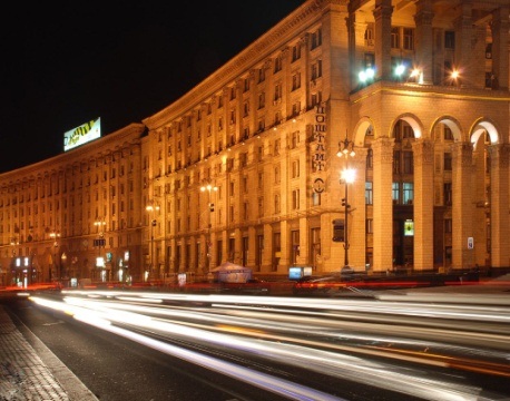
Khreshchatyk is the main street of Kyiv and one of the most famous boulevards in Eastern Europe. It stretches for just 1.2 kilometres from Bessarabska Square to European Square, yet its average width of 75 metres — reaching 100 metres in some sections — gives it the scale of a grand European avenue. A chestnut-tree promenade runs along its right side, at its most spectacular in late April and May when the trees come into bloom, filling the entire street with white and pink flowers.
History
Khreshchatyk began to take shape as a street at the turn of the 18th and 19th centuries, initially developing around the area now known as European Square. The name is thought to derive either from the nearby site where Prince Volodymyr baptised his family and retinue, making it a place of the “cross” (khrest), or from the old toponym Khreshchatyi Yar — a ravine system that once crossed the valley here. By 1869 the street had been renamed from the older form “Khreshchatytska” to the shorter modern name.
By the late 19th century, Khreshchatyk had become Kyiv′s commercial and social heart. Banks, hotels, shops and offices lined its buildings. In 1892, the city opened the first electric tram line in the Russian Empire on this street, connecting Khreshchatyk with the historic Podil district below. The celebrated architect Vladislav Horodetsky designed the House of the Russian Insurance Society at the corner of Khreshchatyk and Prorizna Street in the early 20th century — one of several distinguished buildings that gave the pre-war street its character. By 1914 the grand Passazh arcade had been added. Around the same time, the Bessarabsky Covered Market and the building of the Merchants′ Assembly (today the National Philharmonic of Ukraine) were completed, both of which survive as city landmarks today.
The most dramatic chapter in Khreshchatyk′s history came in September 1941, when Soviet NKVD agents detonated explosive charges hidden throughout the city centre, destroying almost the entire street in a series of fires and blasts that burned for days. After the city′s liberation in 1943, reconstruction began almost immediately. By 1948, a bold new vision for the street had been agreed: the right side was raised by two metres, buildings were set back further from the road, and the famous chestnut promenade was planted. The resulting architecture — often described as “Stalinist Empire” style — gives Khreshchatyk its current monumental appearance. The width of the street was increased from the pre-war 35 metres to its current 75 metres.
Since the late 1990s, Khreshchatyk is closed to traffic on weekends and public holidays, transforming into a pedestrian boulevard. It is the traditional venue for national celebrations, marathons, festivals and public gatherings, and continues to be the living centre of Kyiv′s public life.
Maidan Nezalezhnosti (Independence Square), situated at the heart of Khreshchatyk, is Ukraine′s most symbolically important public space — the site of the 2004 Orange Revolution and the 2013–2014 Revolution of Dignity, which fundamentally changed the course of Ukrainian history.
Legend: According to a local story, during excavations near Khreshchatyk in 1917, workers unearthed a large metallic cylinder of unknown origin which could not be removed and was reburied. When ruins were cleared after World War II, the object was reportedly found again, cut open, and taken away to an unknown destination. Whether or not the legend is true, it has given Khreshchatyk an air of mystery that locals enjoy retelling.
Andriivsky Uzviz
How to get there: Take the metro to Zoloti Vorota (green line) and walk down Volodymyrska Street to the top of the descent; or take the metro to Kontraktova Ploshcha (blue line) and walk up from Podil past the Samson Fountain.
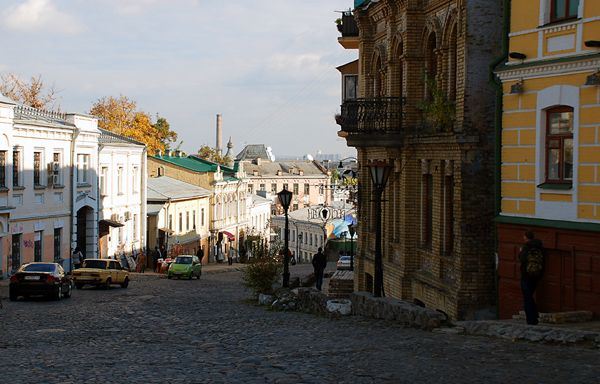
Andriivsky Uzviz — St Andrew′s Descent — is without question the most romantic and atmospheric street in Kyiv. This winding cobblestone lane tumbles down from the ancient Upper Town, past the baroque silhouette of St Andrew′s Church, to the historic Podil district and Kontraktova Square below. Bohemian, historic, slightly theatrical and always surprising, it is unlike any other street in the city.
History
The upper section of the street has existed since the time of Kievan Rus, serving as the main connection between the hilltop citadel and the river trading district of Podil. For centuries it was passable only on foot or horseback. In the early 18th century, by order of the Kyiv governor, the descent was widened enough to allow ox-drawn carts. The street was named after the Apostle Andrew, who, according to the Primary Chronicle of Nestor, climbed these very hills around two thousand years ago, erected a cross, and prophesied the founding of a great Christian city on the Dnipro slopes.
After the October Revolution of 1917, the street was renamed after a Soviet figure, but in 1944 its historic name was restored. Today Andriivsky Uzviz is officially designated a street-museum and is one of the most visited destinations in Kyiv.
What to See
Every step along Andriivsky Uzviz brings something new:
- St Andrew′s Church — the magnificent baroque church designed by Bartolomeo Rastrelli (1754) stands at the very top of the descent, commanding a sweeping view over Podil and the Dnipro
- Bulgakov Museum — the house at No. 13 where Mikhail Bulgakov lived and worked, immortalised in his novel The White Guard; a small but evocative museum dedicated to the writer and his family
- Richard′s Castle (Zamok Richarda) — a neo-Gothic mansion at No. 15, one of the most mysterious and visually striking buildings in Kyiv, surrounded by ghost stories and urban legends
- Monument to Pronya and Svirid — the beloved bronze statues of the comic couple from the Ukrainian film classic Za dvoma zaytsiamy (Chasing Two Hares), perpetually surrounded by tourists and photographers
- Park of sculptures by Ivan Kavaleridze — an open-air collection of works by the Ukrainian sculptor, painter and film director
- Museum of One Street — an intimate museum entirely devoted to the history and personalities of Andriivsky Uzviz itself, from its earliest days to the present
- Art galleries, craft workshops and studios — the street is lined with painters, printmakers, jewellers and craftspeople selling original works; the outdoor market is particularly lively on summer weekends
Legend: According to an ancient Kyivan legend, a prehistoric sea once covered the land where the Dnipro flows today. The Apostle Andrew climbed the hill, planted a cross and blessed the slopes — and the waters receded, hiding themselves beneath Andriivska Hill. When the first church was built here, a hidden spring was discovered beneath its foundations. For this reason, St Andrew′s Church has never had bells: local tradition holds that if a bell were to ring, the sleeping waters would awaken and flood not only Kyiv, but the entire left bank of the Dnipro.
Both streets are best explored on foot, at a leisurely pace with time for a coffee stop along the way. For a guided walking tour of Khreshchatyk, Maidan Nezalezhnosti and Andriivsky Uzviz, contact us via our Contacts page or use the booking form.